'%3E%3Cmask id='b' fill='%23fff'%3E%3Cuse xlink:href='%23a'/%3E%3C/mask%3E%3Cuse fill='%23414141' xlink:href='%23a'/%3E%3Cg mask='url(%23b)' fill='%23414141'%3E%3Cpath d='M-160-170h300v300h-300z'/%3E%3C/g%3E%3C/g%3E%3C/g%3E%3C/svg%3E)
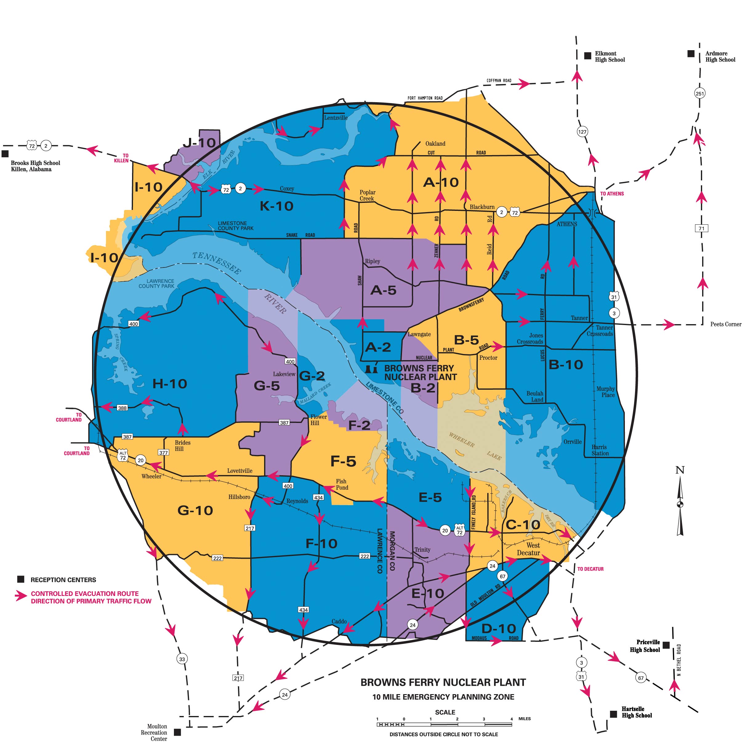
Browns Ferry Emergency Planning Zone Sectors
Use this guide to find your sector; then refer to Browns Ferry Evacuation Routes to navigate to the nearest shelter.
Browns Ferry evacuation map and routes
Select the image to view a high-resolution map.
Two-Mile Zone
Sector A-2—Limestone County
Area within a two-mile radius of the Browns Ferry Nuclear Plant. Beginning at Shaw Road and Poplar Point Road, go due east to Mack Road, south on Mack Road, east on Lawngate Road to Brownsferry Road, then south on Brownsferry Road to Nuclear Plant Road, then due south to the Limestone and Morgan County line on the Tennessee River, then follow that line northwest to a point on the Tennessee River due west of Poplar Point Road, then east to the beginning point on Shaw Road.
Sector B-2—Limestone County
Area within a two-mile radius of the Browns Ferry Nuclear Plant. Beginning at the intersection of Lawngate Road and Brownsferry Road, go southeast to the intersection of Nuclear Plant Road and Cowford Road, then due south to the Limestone and Morgan County line on the Tennessee River, then follow that line northwest to the Limestone and Morgan County line on the Tennessee River that is due south of Brownsferry Road and Nuclear Plant Road, then north to the beginning point at the intersection of Lawngate Road and Brownsferry Road.
Sector F-2—Lawrence County
Beginning on County Road 387 (east of Flower Hill), go southeast along the Wheeler Reservation boundary to the shoreline of the south side of the Tennessee River, then go northwest along the shoreline until it meanders back to the point of beginning at County Road 387.
Sector G-2—Lawrence County
Beginning at a point on County Road 400 at Flower Hill at intersection of County Road 387, go east
on County Road 387 to the south shoreline of the Tennessee River, then go west along the shoreline
to the Mallard Creek Bridge (County Road 400). Proceed north on County Road 400 to power line,
continue due north from power line to the south
shoreline of the Tennessee River, then go east along the shoreline of the Tennessee River as it meanders
around the Mallard Creek Public Use Area, and back to the Mallard Creek Bridge on County Road 400.
Five-Mile Zone
Sector A-5—Limestone County
Area between a two- and five-mile radius of the Browns Ferry Nuclear Plant. Beginning at the intersection of
Snake Road and Fielding Road, go east to past the dead end of Snake Road, then southeast to the intersection of
Zehner Road and Grubbs Road, then east to Blackburn Road, then south to Ripley Road, then southeast to
Brownsferry Road, then southwest to the intersection of Brownsferry Road and Lawngate Road, then west to
Mack Road, north on Mack Road to a point due east of Popular Point Road, then west to the Limestone
and
Lawrence County line on the Tennessee River, then
follow line northwest to the Limestone and Lawrence County line on the Tennessee River, southwest of the
90-degree turn on Friend Road, then northeast to the 90-degree turn on Friend Road, then due north to the
intersection of Friend Road and Snake Road.
Sector B-5—Limestone County
Area between a two- and five-mile radius of the
Browns Ferry Nuclear Plant and southeast of Brownsferry Road. Beginning at the intersection of
Brownsferry Road and Lawngate Road, go northeast to the intersection of Ripley Road and Brownsferry
Road, then southeast on Ripley Road to Huntsville Brownsferry Road, then south to Neely Road, then
due south to Beulah Bay, then west around Beulah Bay, then south to the Limestone and Morgan County
line on the Tennessee River, then northwest to the Limestone and Morgan County line on the Tennessee
River, due south of Cowford Road, then north to the intersection of Cowford Road and Nuclear Plant
Road, then northwest to the beginning point of Lawngate Road and Brownsferry Road.
Sector E-5—Morgan County
Beginning at the intersection of Lawrence County line
and State Highway 20, go north along the county line to the Limestone County line on the Tennessee River,
east along the county line (on water) to Finley Island Road, south on Finley Island Road to State Highway
20, west on Highway 20 to point of beginning.
Sector F-5—Lawrence County
Beginning at Flower Hill on County Road 400, go east on County Road 387 to the Wheeler Reservation
boundary, then follow the Wheeler Reservation boundary to the Lawrence-Morgan County line. Follow
the Lawrence-Morgan County line south to State Highway 20, then go west on State Highway 20 to
County Road 432 to the intersection of County Road 433, then west and north on County Road 433 until it
intersects again with State Highway 20. Go west on State Highway 20 to the intersection of County Road
400, then north on County Road 400 to Flower Hill.
Sector G-5—Lawrence County
Beginning at Flower Hill, proceed south on Mallard Creek Road (County Road 400) to State Highway 20.
Go west on State Highway 20 approximately one mile to County Road 383, north approximately 3/4 mile
to the intersection of County Road 384, then west, north and east along County Road 384. Go back to
County Road 383, then north on County Road 383 to the intersection of County Road 387, then west
approximately one mile on County Road 387 to intersection of County Road 423. Go north and east
to the end of County Road 423, then due north to the Lawrence County line on the Tennessee River, then
east-southeast along the Lawrence County line to the power line on County Road 400, then south on Mallard
Creek Road (County Road 400) back to Flower Hill.
Ten-Mile Zone
Sector A-10—Limestone County
Area between a five- and 10-mile radius of the Browns
Ferry Nuclear Plant. Beginning at the intersection of Gordon Road and Snake Road, go north to New Cut
Road, then follow New Cut Road to Baker Hill Road, then north to Elk River Mills Road, then northwest
to 10-mile radius, then east on the 10-mile radius to Elk River Mills Road, then east to Highway 99, then
southeast to Jefferson Street, then south on Jefferson Street, then west on Washington Street, then south on
Madison Street to Brownsferry Road, then southwest to Ripley Road, then west to Blackburn Road, then
north to Grubbs Road, then east to Zehner Road, then northwest to a point just past the dead end of Snake
Road, then west to Gordon Road.
Sector B-10—Limestone County
Area between a five- and 10-mile radius of Browns Ferry Nuclear Plant. Beginning at Ripley Road and Brownsferry Road, go northeast to Madison Street, then north to Washington Street, then east on Washington Street, then south on Clinton Street to U.S. 72 East, then south on U.S. 31, then south to bank of the river, then follow bank of river to 10-mile radius, then south to the Limestone and Morgan County line on the Tennessee River, then northwest to the Limestone and Morgan County line on the Tennessee River, due south of Neely and Settle Road, then north to Beulah Bay, then west around Beulah Bay, then north to the intersection of Huntsville Brownsferry Road and Neely Road, then northwest on Huntsville Brownsferry Road to beginning point at Brownsferry Road.
Sector C-10—Morgan County
Beginning at Limestone County line and Finley Island
Road, go south on Finley Island Road to Woodall Road, south on Woodall Road to State Highway 24,
east on Highway 24 to Moulton Street (Highway 24). Go east on Moulton Street to the railroad, north on
the railroad to the Tennessee River, northwest on river to Finley Island Road and Limestone County.
Sector D-10—Morgan County
Beginning at Woodall Road and Highway 24, go south on
Woodall Road (Shady Grove Lane) to Modaus Road, east on Modaus Road to Danville Road, north on Danville Road
(Memorial Drive) to Moulton Street, west on Moulton Street (Highway 24) to Woodall Road and Highway 24.
Sector E-10—Morgan County
Beginning at intersection of State Highway 20 and
Lawrence County line, go south along county line to State Highway 24, then northeast on Highway 24 to
Whitlow Road. Follow Whitlow Road to Hudson Road, go east along Hudson Road to Old Moulton Road,
then go northeast on Old Moulton Road to Woodall Road, north on Woodall Road to State Highway 20,
west on Highway 20 to Lawrence County line.
Sector F-10—Lawrence County
Beginning on State Highway 20 at the Lawrence- Morgan County line, go west on State Highway 20 to County Road 432, then south on 432 to the intersection of County Road 433, then west and north on County Road 433 until it intersects again with State Highway 20. Go west on State Highway 20 to the intersection of County Road 217, then south on County Road 217 to the intersection of County Road 301 at Sulphur Spring. Follow County Road 301 until the road runs into County Road 299, then follow County Road 299 until the road runs into County Road 214; remain on County Road 214 east to Lawrence-Morgan County line, then north along the Lawrence-Morgan County line to the point of beginning on State Highway 20.
Sector G-10—Lawrence County
Beginning at the intersection of State Highway 20 and County Road 383, go north on County Road 383 to intersection of County Road 384, then north and east along County Road 384 back to County Road 383. Go north on County Road 383 to the intersection of County Road 387, then west on County Road 387 to State Highway 20, then west on State Highway 20 to the intersection of State Highway 33. Proceed south on State Highway 33 to the intersection of County Road 222, then east on County Road 222 to the intersection of County Road 294, then follow a line southeast by Blowing Springs Branch to the intersection of County Road 217 at Sulphur Springs. Go north on County Road 217 to State Highway 20, then east on State 20 to point of beginning.
Sector H-10—Lawrence County
Beginning at the intersection of County Road 387 in the vicinity of Terry Heights subdivision, go east along County Road 387 5.4 miles to County Road 423, then north to the end of County Road 423. Proceed due north to the Lawrence County line at the Tennessee River, then westerly along the county line to a point due north of the TVA Public Use Area, then south to the Spring Creek Road bridge. Follow Spring Creek Road (County Road 400) south to County Road 389, south on County Road 389 to Jefferson Street, then east on Jefferson Street to State Highway 33, to Terry Heights subdivision.
Sector I-10—Lauderdale County
Beginning at Elk River Bridge at U.S. Highway 72, go west to County Road 77, south on County Road 77 to Barnett Road, south on Barnett Road to curve in the road, then a southwest angle to the intersection of County Road 632 and County Road 91. Go north on County Road 91 to the intersection of Longshore Drive, then south on Longshore Drive to Tennessee River to Lauderdale County line. Follow Lauderdale County line east, then north to beginning point at U.S. 72 at Elk River Bridge.
Sector J-10—Lauderdale County
Beginning at Elk River Bridge at U.S. Highway 72, go west on U.S. Highway 72 to County Road 70, north on County Road 70 to the intersection of County Road 70 and County Road 566, then east on County Road 566 to Richter Road at Lauderdale County line. Go south on Richter Road following Lauderdale County line to Elk River, and then following Lauderdale County line to beginning point at Elk River Bridge at U.S. Highway 72.
Sector K-10—Limestone County
Area between a five- and 10-mile radius of the Browns Ferry Nuclear Plant. Beginning at the intersection of Gordon Road and Snake Road, go west to Friend Road, then south to 90-degree turn on Friend Road, then southwest to the Limestone and Lawrence County line on the Tennessee River, then west along river line to the center of Elk River, then northwest along center to bank of Elk River. Follow shore along west bank of Elk River to Richter Road, then north to the 10-mile radius and follow to Elk River Mills Road, then southeast to Baker Hill Road, then south to New Cut Road, then southwest to Gordon Road, then south to beginning point of Gordon Road and Snake Road.