'%3E%3Cmask id='b' fill='%23fff'%3E%3Cuse xlink:href='%23a'/%3E%3C/mask%3E%3Cuse fill='%23414141' xlink:href='%23a'/%3E%3Cg mask='url(%23b)' fill='%23414141'%3E%3Cpath d='M-160-170h300v300h-300z'/%3E%3C/g%3E%3C/g%3E%3C/g%3E%3C/svg%3E)
Sequoyah Evacuation Routes
Controlled evacuation routes are established for the purpose of helping the traffic flow.
Select the image to view the high-resolution map.
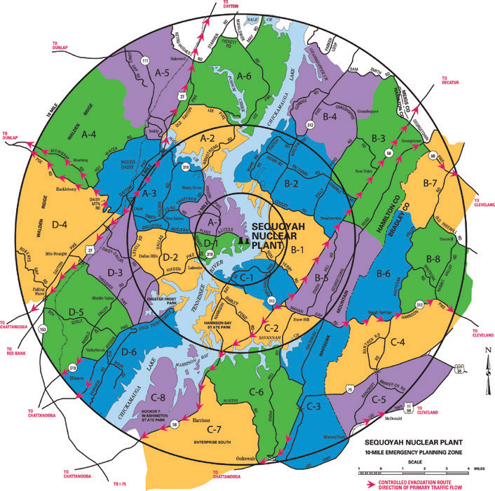
These routes will be patrolled by law enforcement officers and traffic-assist teams. In addition, if you are not familiar with the area or your shelter assignment, shelter information points will be set up on each route to assist in getting you to your assigned shelter. The controlled evacuation routes are indicated by arrows on the evacuation map below and are as follows:
US Highway 27: North from the intersection of Sequoyah Access Road into Rhea County and
south from the intersection into Chattanooga
State Route (SR) 58: North from the intersection of Igou Ferry Road into Meigs County and south from the intersection into Chattanooga
Mowbray Pike:
West into Sequatchie County to Dunlap
Hixson Pike: South into Chattanooga
Middle Valley Road: South into Chattanooga
Georgetown Road: East into Cleveland
Harrison Pike: East into Cleveland
South Lee Highway: East into Cleveland
A-1, A-2, A-5
To: Rhea Central Elementary School, 1005 Delaware Ave., Dayton TN, 37321 (Rhea County)
Take the most direct route from your location to US 27; go north on US 27 and take the Business Route into Dayton to Delaware Avenue; turn left on Delaware to the school, located at 1005 Delaware Avenue at the corner of Delaware and SR 30 West.
A-3, A-6
To: Rhea County Middle School, 405 Pierce Road, Evensville, TN 37332 (Rhea County)
Take the most direct route from your location to US 27; go north on US 27 into Rhea County through Dayton to Evensville;
turn left on Eagle Lane.
A-4
To: Sequatchie County High School, 7067 TN-28 Scenic, Dunlap, TN 37327 (Sequatchie County)
Take the most direct route from your location to
Mowbray Pike; go west on Mowbray Pike and turn right onto Henson Gap Road; go west on Henson
Gap Road into Sequatchie County and turn right onto Jimmy Johnson Road; go north and turn left onto
North TN 111; go north on TN 111 to U.S. 127; turn left on U.S. 127 and go to SR 28; turn right on SR 28
to the school on the right.
B-1, B-2, B-3, B-4, B-5
To: Meigs County High School, 105 Abel Ave., Decatur, TN 37322 (Meigs County)
Take the most direct route from your location
to SR 58; go north on SR 58 into Meigs County to Decatur; go through the intersection with SR 30 and turn left on West Memorial Drive; go three blocks on West Memorial Drive and turn right on School Drive to the school on the right.
B-6, B-8
To: Ocoee Middle School, Ocoee Street at 23rd Street, Cleveland, TN 37311 (Bradley County)
Take the most direct route from your location to Harrison Pike into Cleveland;
turn left on Keith Street and go to 25th Street; turn right and go to Ocoee Street; turn right on Ocoee Street and go to the shelter at Ocoee and 23rd streets.
B-7
To: Ocoee Middle School, Ocoee Street at 23rd Street, Cleveland, TN 37311 (Bradley County)
Take the most direct route from your location to Georgetown Road
into Cleveland to 25th Street; follow 25th Street to Ocoee Street; turn right on Ocoee Street and go to the shelter at Ocoee and 23rd streets.
C-1, C-2
To: Brainerd High School, 1020 N. Moore Road, Chattanooga, TN 37411 (Hamilton County)
Take the most direct route from your location to SR 58; go south on SR 58 to SR 153; go south on SR 153 to Lee Highway/Brainerd Road; turn right on Brainerd Road and go to North Moore Road; turn right on North Moore and go to the school at 1020
North Moore Road.
C-3, C-6
To: East Ridge High School, 4320 Bennett Road, East Ridge, TN 37412 (Hamilton County)
Take the most direct route from your location to SR 58; go south on SR 58 to
SR 153; go south on SR 153 to I-75 South; go south on I-75 to the East Ridge exit; turn right on Ringgold Road to Tombras Road (traffic light No. 8); turn left on Tombras Road to Bennett Road; turn right and go to the school on the left at 4320
Bennett Road.
C-4, C-5
To: Ocoee Middle School Ocoee Street at 23rd Street, Cleveland, TN
37311 (Bradley County)
Take the most direct route from your location to South Lee Highway or Harrison Pike into Cleveland to Keith Street. Go north on Keith Street to 25th Street; turn right on
25th Street and go to Ocoee Street; turn right on Ocoee Street and go to the shelter at Ocoee and 23rd streets.
C-7
To: East Lake Academy, 2700 E. 34th Street, Chattanooga, TN 37407 (Hamilton County)
Take the most direct route from your location to SR 58; go south on SR 58 to SR 153; go south on SR 153
to I-75 South; go south on I-75 to I-24 West; go west on I-24 to the Fourth Avenue exit; turn left on Fourth
Avenue to East 34th Street; turn left on East 34th Street to Dodds Avenue; school is on the right at 2700
E. 34th Street.
C-8
To: Dalewood Middle School, 1300 Shallowford Road, Chattanooga, TN 37411 (Hamilton County)
Take the most direct route from your location to SR 58; go south on SR 58 to SR 153; go south on SR 153 to the
Shallowford Road exit; turn right and go to the school at 1300 Shallowford Road.
D-1, D-6
To: Chattanooga High Center for Creative Arts, 1301 Dallas Road, Chattanooga, TN 37405 (Hamilton County)
Take the most direct route from your location to Hixson Pike; go south on Hixson Pike to Fernway Road; Fernway Road will turn into Old Dallas Road; continue on Old Dallas Road to Dallas Road; continue on Dallas Road to the school, located at
1301 Dallas Road.
D-2, D-3
To: Red Bank High School, 640 Morrison Springs Road, Chattanooga, TN 37415 (Hamilton County)
Take the most direct route from your location to Highway 27 South; go south on Highway 27 South to Morrison Springs; exit onto the Morrison Springs exit ramp; turn right onto Morrison Springs from the exit ramp; turn left onto South Quail Lane to Red Bank High School at 640 Morrison Springs Road.
D-4, D-5
To: Howard School of Academics and Technology, 2500 Market Street, Chattanooga, TN 37408 (Hamilton County)
Take the most direct route from your location to US 27; go south on US 27 to the I-24 interchange; take the Lookout Mountain/South Broad Street exit onto Williams Street; go to 26th Street; turn left on 26th Street and go to Market Street. The
school is at 2500 South Market Street.