'%3E%3Cmask id='b' fill='%23fff'%3E%3Cuse xlink:href='%23a'/%3E%3C/mask%3E%3Cuse fill='%23414141' xlink:href='%23a'/%3E%3Cg mask='url(%23b)' fill='%23414141'%3E%3Cpath d='M-160-170h300v300h-300z'/%3E%3C/g%3E%3C/g%3E%3C/g%3E%3C/svg%3E)

Dam Tough
TVA Teams Keep Nolichucky and Valley-Region Dams Strong
Three members of Tennessee Valley Authority’s Dam Safety team inched along the cliffside, where the Nolichucky Dam crested to meet rugged limestone and shale.
Above, winter-dry oak and beech leaves rattled against a deep blue sky.
“There used to be a trail here,” Matt Huebner, Dam Safety Risk program manager, said.
Alongside him, Jeff Munsey and Harrison Strickland picked their way through tangled branches and tree trunks that Hurricane Helene’s floodwaters had piled on the reservoir’s shores.
They hiked here for a close-up look at the cliffs, aiming to see if the flood’s scouring power had eroded rocks securing the dam.
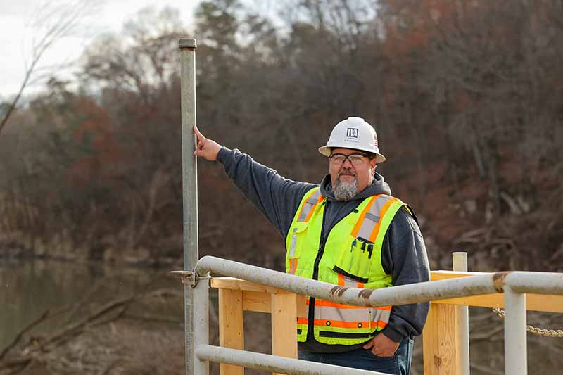
“We’re always working to understand the risks at our dams,” Strickland, TVA’s Public Safety Around Dams program manager, said. “Public safety is our No. 1 priority.”
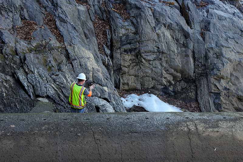
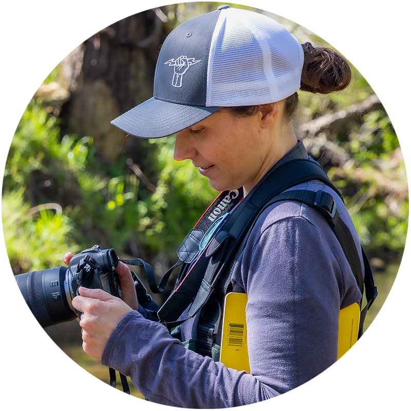
Matt Huebner, TVA Dam Safety Risk program manager, assesses cliffs for dam safety at Nolichucky.
Rock Solid
TVA’s Dam Safety team – engineers, geologists, river and reservoir managers, aviators and divers – studies land and water resources to ensure the Valley region’s dams are safe.
TVA’s geologists, for example, travel the region to map and assess dam risks based on rock type and position. Sturdy rock is critical to safe structures.
At Nolichucky, they focused on changes in rock crags and cracks, called discontinuities or joints.
These matter because, at these fractures, rock could be more likely to break under stress from rushing water or raging winds.
Mapping after extreme events helps geologists refine their understanding of the rock and its behavior, particularly when compared to earlier predictions.
“We worked with TVA’s aviation team to collect lidar data at Nolichucky in 2021,” Huebner said. “So we have this incredible baseline data set.”
That data featured high-resolution, 3-D images of the ground before the flooding.
Rocks, trees, buildings. Everything.
“And then Helene happened,” Huebner said. “That flood event was very rare and very strong, so we can model rock plucking and rock scouring. We have something to calibrate it now.”
On this expedition, Huebner boosted himself over massive boulders to get a first look at rock that floodwaters had stripped clean of vegetation and debris.
As Huebner snapped photos of joints and other features, Munsey peered downriver at vertically stacked layers of a flood-scoured cliff. He and Huebner had walked here in the months after Helene.
“It’s almost unprecedented … to see this much geologic exposure,” Munsey, Dam Safety risk and emergency safety preparedness group manager, said, shaking his head. “It’s a view of the bedrock that one normally only sees ... in the western U.S.”
Their new data will help the team better understand how floodwaters can affect these rock formations. They’ll share those findings widely, ensuring the entire Valley region has access to information that bolsters dam safety.
“It's important to understand the geology when you’re thinking about risk assessment of dams,” Huebner said, packing away his tablet and tools. “This goes beyond just TVA. This is really helping the greater community.”
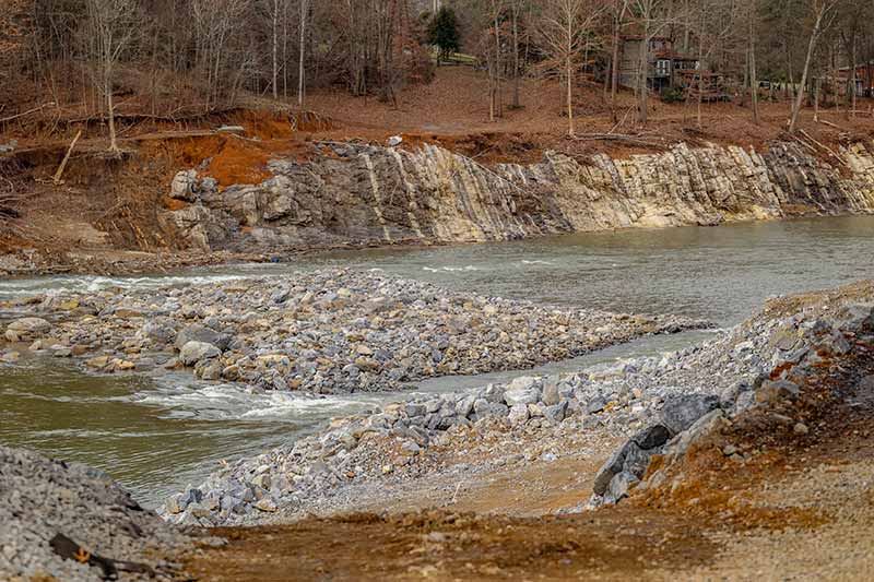
Floodwaters following Hurricane Helene brought such high flow to the Nolichucky River that this rock island moved downriver.
Sonar for Safety
Deep underwater, Johnny Cash snapped photographs of the dam’s craggy surface.
Cash, an underwater remote-operated vehicle, or ROV, earned its name during an inaugural dive at Nickajack Dam.
“Supposedly, Johnny Cash wrote a song at Nickajack in a cave,” TVA Dam Safety inspector and civil engineer Wesley Jaynes explained.
He and the Dam Safety team use microwave-sized ROVs like Cash to inspect 49 dams across the Valley region.
While divers do some of the underwater work, remote-operated vehicles equipped with cameras, 2-D or 3-D sonar, and pinchers that can grip or scoop samples are especially useful in conditions unsafe for people.
“It’s on a tether, so we can drop it off over a wall or from a boat,” Jaynes said.
The ROVs are guided by remote control and GPS to precise locations, enabling the team to take photos or video of a dam’s specific features. The images are compared to previous ones to spot changes over time.
At Nolichucky, the team worked with a specialized contractor to collect sonar data.
“It basically does a 360-degree scan,” Jaynes said. “Imagine a radar scan when you’re looking at the weather. They let those data points overlap, then they have software that will compile that together and create a larger image with all those scans.”
More advanced scans can provide incredibly detailed information about underwater features. That can be merged with above-ground lidar data to create a 3-D, interactive model.
These high-tech approaches ultimately provide a long-term understanding of any changing conditions.
“Things are going to happen – rock is going to erode, concrete is going to spall,” Jaynes said. “But we’re looking at it over time to decide when it’s a problem that we need to address.”
After Helene, sonar scans at Nolichucky Dam showed all is well.
“TVA has always had a close watch of all the parts of the dam, above water, below water,” Jaynes said. “I think what we’ve added with sonar is … a true picture of what the dam looks like. There’s a lot of satisfaction to accomplish something like that.”
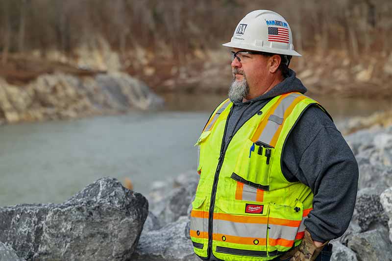
Harry Burnsworth, TVA construction manager, below Nolichucky Dam following record floods after Hurricane Helene.
Into the Future
During and after Hurricane Helene, everyone watched Nolichucky Dam carefully.
The water had roared over the top with almost twice the flow of Niagara Falls.
“She held up good in that flood,” Harry Burnsworth, TVA construction manager for the Nolichucky repairs project, said.
He stood above the dam spillway and pointed at the changed landscape and the rebuilding efforts underway. At the north end of the dam, crews had rebuilt the flood-damaged banks with boulders.
“That used to be an island up here, closer to the bridge,” he said, nodding at a bare pile of boulders. “It had trees on it. Now it's washed down there and it's just rock. That's how powerful that water was – it displaced that island.”
The first step toward recovery was cleanup.
“We shut the dam gates, let the water drop down and made a temporary road to the island,” Burnsworth said. “They walked the machine out there and picked up all the debris.”
After demolishing the damaged powerhouse, TVA crews and contractors began touching up spalling on the dam’s face.
“Spalling is like where chipping occurs in concrete – a piece is missing,” Burnsworth said. “During the storm, trees and debris chipped away some of the concrete. So now we're cleaning those areas out and repacking them with new concrete. Nothing structural. Just superficial.”
Amid the snow, cold rains and frigid temperatures, crews have worked efficiently.
“We make sure that we're keeping it inside of our boundaries, being the most cost effective and environmentally friendly,” Burnsworth said. “We didn't change the path of the river. We’re repairing and protecting what's left.”
And they’re thinking to the future to determine how the dam and the site surrounding can serve multiple needs.
“We've got a lot of people involved,” Burnsworth said. “We're trying to get everybody's buy-in on how we should leave this in the final state – make sure it's excellent as far as dam quality, dam safety and the safety of the public."
Strickland agreed – it’s about safety, but also public access to recreation and natural resources for residents boating and fishing on rivers up and downstream from TVA’s dams.
“That’s what we’re here for,” he said.
Many area residents have been receptive. One even brought Burnsworth’s crew doughnuts. Another – a retired engineer who fishes the Nolichucky River – stopped by to see the progress.
“He gave us kudos on how good everything looks and how quickly we responded,” Burnsworth said. “We've heard that a lot, that there's a lot done in a short period of time.”
Photo Gallery
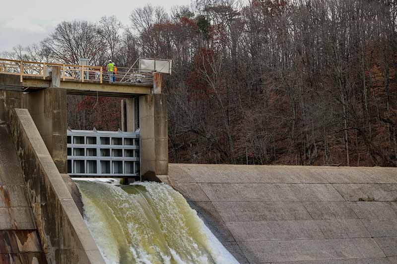
Nolichucky Dam withstood record water flow following Hurricane Helene.
Burnsworth shows how high water levels reached during flooding after Hurricane Helene.
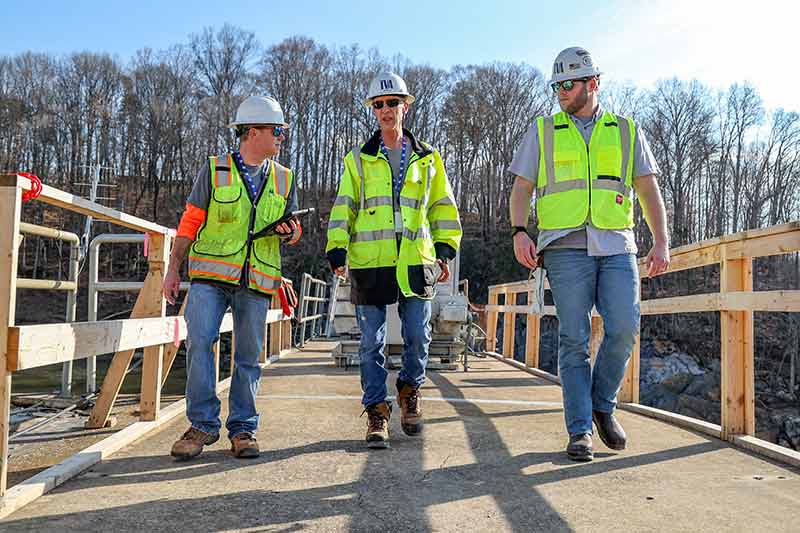
Huebner, Jeff Munsey, Dam Safety risk and emergency safety preparedness group manager, and Harrison Strickland, TVA Public Safety Around Dams program manager, on Nolichucky Dam.
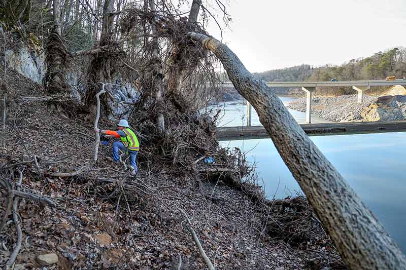
Huebner scrambles through hurricane-damaged areas to reach cliffs at Nolichucky Dam.
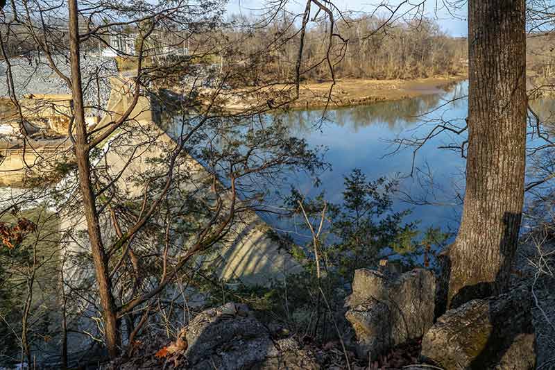
Nolichucky Dam.
PHOTO AT TOP OF PAGE: A crew evaluates and makes minor repairs to Nolichucky Dam following record-high flow after Hurricane Helene.
Susan Ehrenclou
Staff Writer
Share this story: ' fill='%23414141'%3E%3Cpath d='M0 0h314v314H0z'/%3E%3C/g%3E%3Cg transform='translate(6 4)'%3E%3Cmask id='d' fill='%23fff'%3E%3Cuse xlink:href='%23c'/%3E%3C/mask%3E%3Cuse fill='%23FFF' xlink:href='%23c'/%3E%3Cg mask='url(%23d)' fill='%23FFF'%3E%3Cpath d='M-149-165h300v318h-300z'/%3E%3C/g%3E%3C/g%3E%3C/g%3E%3C/svg%3E%0A)
' fill='%23414141'%3E%3Cpath d='M0 0h314v314H0z'/%3E%3C/g%3E%3Cg transform='translate(4 5)'%3E%3Cmask id='d' fill='%23fff'%3E%3Cuse xlink:href='%23c'/%3E%3C/mask%3E%3Cuse fill='%23FFF' xlink:href='%23c'/%3E%3Cg mask='url(%23d)' fill='%23FFF'%3E%3Cpath d='M-167-171h323v327h-323z'/%3E%3C/g%3E%3C/g%3E%3C/g%3E%3C/svg%3E%0A)
' fill='%23414141'%3E%3Cpath d='M0 0h314v314H0z'/%3E%3C/g%3E%3Cg transform='translate(4.26 4)'%3E%3Cmask id='d' fill='%23fff'%3E%3Cuse xlink:href='%23c'/%3E%3C/mask%3E%3Cuse fill='%23FFF' xlink:href='%23c'/%3E%3Cg mask='url(%23d)' fill='%23FFF'%3E%3Cpath d='M-150-157h300v300h-300z'/%3E%3C/g%3E%3C/g%3E%3C/g%3E%3C/svg%3E)
Want more stories from The Powerhouse? Sign up to receive a monthly digest in your email.
Dam Safety Awareness
May 31 is National Dam Safety Awareness Day. TVA's Dam Safety program ensures dams are designed, constructed, operated and maintained for safety and reliability. The teams inspect, maintain and repair more than 140 structures that include power-generating dams and dams designed for flood control and recreation, Raccoon Mountain pumped storage and other structures such as dikes and saddle dams.
From Floods to Fault Lines
At Nolichucky Dam, limestone and shale cliffs from the Knox and Conasauga groups formed in horizontal layers during the Ordovician Period 485 million to 444 million years ago.
When tectonic plates pushed together to form Appalachian Mountain peaks and folds of the Valley and Ridge province, Nolichucky’s rock layers flipped vertically like books on a shelf.
The geology of the Southeast means that floods are only one of many risks the Dam Safety team assesses and prepares for. Another one is earthquakes.
“The Tennessee Valley is sandwiched between the two most active seismicity areas in the East Coast – New Madrid … and the East Tennessee Seismic Zone,” Huebner said.
Munsey began a seismic monitoring program at TVA. He and Huebner now install seismic monitoring equipment throughout the Valley region. These tools will eventually connect to U.S. Geological Survey systems for up-to-date knowledge about dam safety – and the safety of communities throughout the region.